The content of this website is no longer being updated. For information on current assessment activities, please visit http://www.globalchange.gov/what-we-do/assessment
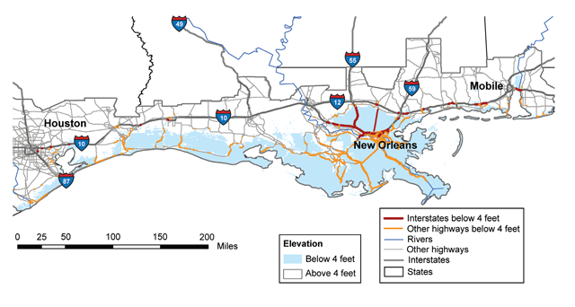
Gulf Coast Area Roads at Risk from Sea-Level Rise

Within 50 to 100 years, 2,400 miles of major roadway are projected to be inundated by sea-level rise in the Gulf Coast region. The map shows roadways at risk in the event of a sea-level rise of about 4 feet, within the range of projections for this region in this century under medium- and high-emissions scenarios.1 In total, 24 percent of interstate highway miles and 28 percent of secondary road miles in the Gulf Coast region are at elevations below 4 feet.2 Image Reference: CCSP SAP 4.72
References
- 1. [91] various. footnote 91., 2009.
- 2. a. b. [217] Kafalenos, R. S., K. J. Leonard, D. M. Beagan, V. R. Burkett, B. D. Keim, A. Meyers, D. T. Hunt, R. C. Hyman, M. K. Maynard, B. Fritsche et al. "What are the Implications of Climate Change and Variability for Gulf Coast Transportation?" In Impacts of Climate Change and Variability on Transportation Systems and Infrastructure: Gulf Coast Study, Phase I, edited by M. J. Savonis, V. R. Burkett and J. R. Potter, 4-1 to 4F-27 [104 pp.]. Vol. Synthesis and Assessment Product 4.7. Washington, D.C.: U.S. Department of Transportation, 2008.
Summary
| High-resolution | High-resolution JPEG |
|---|