The content of this website is no longer being updated. For information on current assessment activities, please visit http://www.globalchange.gov/what-we-do/assessment
Southeast
Observed Changes in Precipitation 1901 to 2007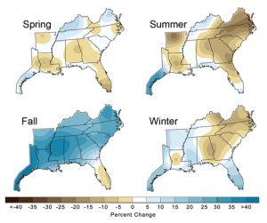 While average fall precipitation in the Southeast increased by 30 percent since the early 1900s, summer and winter precipitation declined by nearly 10 percent in the eastern part of the region. Southern Florida has experienced a nearly 10 percent drop in precipitation in spring, summer, and fall. The percentage of the Southeast region in drought has increased over recent decades. Image Reference: NOAA/NCDC1The climate of the Southeast is uniquely warm and wet, with mild winters and high humidity, compared with the rest of the continental United States. The average annual temperature of the Southeast did not change significantly over the past century as a whole. Since 1970, however, annual average temperature has risen about 2°F, with the greatest seasonal increase in temperature occurring during the winter months. The number of freezing days in the Southeast has declined by four to seven days per year for most of the region since the mid-1970s.
Average autumn precipitation has increased by 30 percent for the region since 1901. The decline in fall precipitation in South Florida contrasts strongly with the regional average. There has been an increase in heavy downpours in many parts of the region,2,3 while the percentage of the region experiencing moderate to severe drought increased over the past three decades. The area of moderate to severe spring and summer drought has increased by 12 percent and 14 percent, respectively, since the mid-1970s. Even in the fall months, when precipitation tended to increase in most of the region, the extent of drought increased by 9 percent.
Climate models project continued warming in all seasons across the Southeast and an increase in the rate of warming through the end of this century. The projected rates of warming are more than double those experienced in the Southeast since 1975, with the greatest temperature increases projected to occur in the summer months. The number of very hot days is projected to rise at a greater rate than the average temperature. Under a lower emissions scenario,4 average temperatures in the region are projected to rise by about 4.5°F by the 2080s, while a higher emissions scenario4 yields about 9°F of average warming (with about a 10.5°F increase in summer, and a much higher heat index). Spring and summer rainfall is projected to decline in South Florida during this century. Except for indications that the amount of rainfall from individual hurricanes will increase,5 climate models provide divergent results for future precipitation for the remainder of the Southeast. Models project that Gulf Coast states will tend to have less rainfall in winter and spring, compared with the more northern states in the region (see precipitation projection maps in the National Climate Change section). Because higher temperatures lead to more evaporation of moisture from soils and water loss from plants, the frequency, duration, and intensity of droughts are likelyat least two-thirds chance of occurring to continue to increase.
| Average Change in Temperature and Precipitation in the Southeast | |||||
|---|---|---|---|---|---|
| Temperature Change in °F | Precipitation Change in % | ||||
| 1901-2008 | 1970-2008 | 1901-2008 |
1970-2008 |
||
| Annual | 0.3 | 1.6 | 6.0 | -7.7 | |
| Winter | 0.2 | 2.7 | 1.2 | -9.6 | |
| Spring | 0.4 | 1.2 | 1.7 | -29.2 | |
| Summer | 0.4 | 1.6 | -4.0 | 3.6 | |
| Fall | 0.2 | 1.1 | 27.4 | 0.1 | |
Observed temperature and precipitation changes in the Southeast are summarized above for two different periods.6 Southeast average temperature declined from 1901 to 1970 and then increased strongly since 1970.
The destructive potential of Atlantic hurricanes has increased since 1970, correlated with an increase in sea surface temperature. A similar relationship with the frequency of landfalling hurricanes has not been established7 8,9,10,11 (see National Climate Change section for a discussion of past trends and future projections). An increase in average summer wave heights along the U.S. Atlantic coastline since 1975 has been attributed to a progressive increase in hurricane power.12,13 The intensity of Atlantic hurricanes is likelyat least two-thirds chance of occurring to increase during this century with higher peak wind speeds, rainfall intensity, and storm surge height and strength.14,12 Even with no increase in hurricane intensity, coastal inundation and shoreline retreat would increase as sea-level rise accelerates, which is one of the most certain and most costly consequences of a warming climate.15
Number of Days per Year with Peak Temperature over 90ºF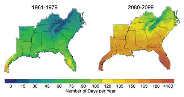 The number of days per year with peak temperature over 90ºF is expected to rise significantly, especially under a higher emissions scenario4 as shown in the map above. By the end of the century, projections indicate that North Florida will have more than 165 days (nearly six months) per year over 90ºF, up from roughly 60 days in the 1960s and 1970s. The increase in very hot days will have consequences for human health, drought, and wildfires. Image Reference: CMIP3-B16
Rising Temperatures
Projected increases in air and water temperatures will cause heat-related stresses for people, plants, and animals.
The warming projected for the Southeast during the next 50 to 100 years will create heat-related stress for people, agricultural crops, livestock, trees, transportation and other infrastructure, fish, and wildlife. The average temperature change is not as important for all of these sectors and natural systems as the projected increase in maximum and minimum temperatures. Examples of potential impacts include:
- Change in Freezing Days per Year 1976 to 2007
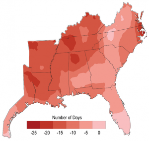 Since the mid-1970s, the number of days per year in which the temperature falls below freezing has declined by four to seven days over much of the Southeast. Some areas, such as western Louisiana, have experienced more than 20 fewer freezing days. Climate models project continued warming across the region, with the greatest increases in temperature expected in summer, and the number of very hot days increasing at a greater rate than the average temperature. Image Reference: NOAA/NCDC17Increased illness and death due to greater summer heat stress, unless effective adaptation measures are implemented.15
 - Decline in forest growth and agricultural crop production due to the combined effects of thermal stress and declining soil moisture.18
- Increased buckling of pavement and railways.19,20
- Decline in dissolved oxygen in stream, lakes, and shallow aquatic habitats leading to fish kills and loss of aquatic species diversity.
- Decline in production of cattle and other rangeland livestock.21 Significant impacts on beef cattle occur at continuous temperatures in the 90 to 100°F range, increasing in danger as the humidity level increases (see Agriculture sector).21 Poultry and swine are primarily raised in indoor operations, so warming would increase energy requirements.22
A reduction in very cold days is likelyat least two-thirds chance of occurring to reduce the loss of human life due to cold-related stress, while heat stress and related deaths in the summer months are likelyat least two-thirds chance of occurring to increase. The reduction in cold-related deaths is not expected to offset the increase in heat-related deaths (see Human Health sector). Other effects of the projected increases in temperature include more frequent outbreaks of shellfish-borne diseases in coastal waters, altered distribution of native plants and animals, local loss of many threatened and endangered species, displacement of native species by invasive species, and more frequent and intense wildfires.
Water Resources
Decreased water availability is very likely to affect the region’s economy as well as its natural systems.
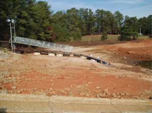 In Atlanta and Athens, Georgia, 2007 was the second driest year on record. Among the numerous effects of the rainfall shortage were restrictions on water use in some cities and low water levels in area lakes. In the photo, a dock lies on dry land near Aqualand Marina on Lake Lanier (located northeast of Atlanta) in December 2007.Decreased water availability due to increased temperature and longer periods of time between rainfall events, coupled with an increase in societal demand is very likely to affect many sectors of the Southeast’s economy. The amount and timing of water available to natural systems is also affected by climate change, as well as by human response strategies such as increasing storage capacity (dams)23 and increasing acreage of irrigated cropland.24 The 2007 water shortage in the Atlanta region created serious conflicts between three states, the U.S. Army Corps of Engineers (which operates the dam at Lake Lanier), and the U.S. Fish and Wildlife Service, which is charged with protecting endangered species. As humans seek to adapt to climate change by manipulating water resources, streamflow and biological diversity are likelyat least two-thirds chance of occurring to be reduced.23 During droughts, recharge of groundwater will decline as the temperature and spacing between rainfall events increase. Responding by increasing groundwater pumping will further stress or deplete aquifers and place increasing strain on surface water resources. Increasing evaporation and plant water loss rates alter the balance of runoff and groundwater recharge, which is likelyat least two-thirds chance of occurring to lead to saltwater intrusion into shallow aquifers in many parts of the Southeast.23
Sea-level Rise and Hurricane Intensity
Sea-level rise and the likelyat least two-thirds chance of occurring increase in hurricane intensity and associated storm surge will be among the most serious consequences of climate change.
Land Lost During 2005 Hurricanes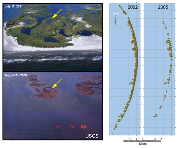 In 2005, 217 square miles of land and wetlands were lost to open water during hurricanes Rita and Katrina. The photos and maps show the Chandeleur Islands, east of New Orleans, before and after the 2005 hurricanes; 85 percent of the islands’ above-water land mass was eliminated. Image Reference: USGS25
An increase in average sea level of up to 2 feet or more and the likelihood of increased hurricane intensity and associated storm surge are likely to be among the most costly consequences of climate change for this region (see National Climate Change section). As sea level rises, coastal shorelines will retreat. Wetlands will be inundated and eroded away, and low-lying areas including some communities will be inundated more frequently – some permanently – by the advancing sea. Current buildings and infrastructure were not designed to withstand the intensity of the projected storm surge, which would cause catastrophic damage. As temperature increases and rainfall patterns change, soil moisture and runoff to the coast are likelyat least two-thirds chance of occurring to be more variable. The salinity of estuaries, coastal wetlands, and tidal rivers is likelyat least two-thirds chance of occurring to increase in the southeastern coastal zone, thereby altering coastal ecosystems and displacing them farther inland if no barriers exist. More frequent storm surge flooding and permanent inundation of coastal ecosystems and communities is likelyat least two-thirds chance of occurring in some low-lying areas, particularly along the central Gulf Coast where the land surface is sinking.26,27 Rapid acceleration in the rate of increase in sea-level rise could threaten a large portion of the Southeast coastal zone. The likelihood of a catastrophic increase in the rate of sea-level rise is dependent upon ice sheet response to warming, which is the subject of much scientific uncertainty (see Global Climate Change section).14 Such rapid rise in sea level is likelyat least two-thirds chance of occurring to result in the destruction of barrier islands and wetlands.28,18
Sea Surface Temperature: Atlantic Hurricane Main Development Region (August through October, 1900 to 2008)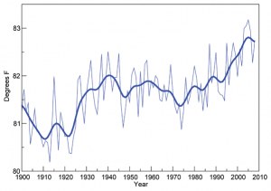 Ocean surface temperature during the peak hurricane season, August through October, in the main development region for Atlantic hurricanes.29 Higher sea surface temperatures in this region of the ocean have been associated with more intense hurricanes. As ocean temperatures continue to increase in the future, it is likely that hurricane rainfall and wind speeds will increase in response to human-caused warming (see National Climate Change section).5 Image Reference: NOAA/NCDC29Compared to the present coastal situation, for which vulnerability is quite high, an increase in hurricane intensity will further affect low-lying coastal ecosystems and coastal communities along the Gulf and South Atlantic coastal margin. An increase in intensity is very likelyat least a 90% chance of occurring to increase inland and coastal flooding, coastal erosion rates, wind damage to coastal forests, and wetland loss. Major hurricanes also pose a severe risk to people, personal property, and public infrastructure in the Southeast, and this risk is likelyat least two-thirds chance of occurring to be exacerbated.26,27 Hurricanes have their greatest impact at the coastal margin where they make landfall, causing storm surge, severe beach erosion, inland flooding, and wind-related casualties for both cultural and natural resources. Some of these impacts extend farther inland, affecting larger areas. Recent examples of societal vulnerability to severe hurricanes include Katrina and Rita in 2005, which were responsible for the loss of more than 1,800 lives and the net loss of 217 square miles of low-lying coastal marshes and barrier islands in southern Louisiana.18,30
Ecosystems
Ecological thresholds are expected to be crossed throughout the region, causing major disruptions to ecosystems and to the benefits they provide to people.
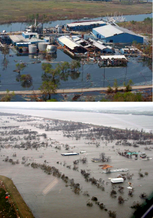 Flooding damage in Louisiana due to Hurricane KatrinaEcological systems provide numerous important services that have high economic and cultural value in the Southeast. Ecological effects cascade among both living and physical systems, as illustrated in the following examples of ecological disturbances that result in abrupt responses, as opposed to gradual and proportional responses to warming:
- The sudden loss of coastal landforms that serve as a storm-surge barrier for natural resources and as a homeland for coastal communities (such as in a major hurricane).31,18
- An increase in sea level can have no apparent effect until an elevation is reached that allows widespread, rapid saltwater intrusion into coastal forests and freshwater aquifers.32
- Lower soil moisture and higher temperatures leading to intense wildfires or pest outbreaks (such as the southern pine beetle) in southeastern forests;33 intense droughts leading to the drying of lakes, ponds, and wetlands; and the local or global extinction of riparian and aquatic species.23
- A precipitous decline of wetland-dependent coastal fish and shellfish populations due to the rapid loss of coastal marsh.34
Society
Quality of life will be affected by increasing heat stress, water scarcity, severe weather events, and reduced availability of insurance for at-risk properties.
Over the past century, the southeastern “sunbelt” has attracted people, industry, and investment. The population of Florida more than doubled during the past three decades, and growth rates in most other southeastern states were in the range of 45 to 75 percent (see population map in Energy sector). Future population growth and the quality of life for existing residents is likely to be affected by the many challenges associated with climate change, such as reduced insurance availability, increased insurance cost, and increases in water scarcity, sea-level rise, extreme weather events, and heat stress. Some of these problems, such as increasing heat and declining air quality, will be especially acute in cities.
Adaptation: Reducing Exposure to Flooding and Storm Surge
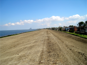 Recent upgrades that raised the height of this earthen levee increased protection against storm surge in the New Orleans area.Three different types of adaptation to sea-level rise are available for low-lying coastal areas.35,36 One is to move buildings and infrastructure farther inland to get out of the way of the rising sea. Another is to accommodate rising water through changes in building design and construction, such as elevating buildings on stilts. Flood insurance programs even require this in some areas with high probabilities of floods. The third adaptation option is to try to protect existing development by building levees and river flood control structures. This option is being pursued in some highly vulnerable areas of the Gulf and South Atlantic coasts. Flood control structures can be designed to be effective in the face of higher sea level and storm surge. Some hurricane levees and floodwalls were not just replaced after Hurricane Katrina, they were redesigned to withstand higher storm surge and wave action.37
The costs and environmental impacts of building such structures can be significant. Furthermore, building levees can actually increase future risks.36 This is sometimes referred to as the levee effect or the safe-development paradox. Levees that provide protection from, for example, the storm surge from a Category 3 hurricane, increase real and perceived safety and thereby lead to increased development. This increased development means there will be greater damage if and when the storm surge from a Category 5 hurricane tops the levee than there would have been if no levee had been constructed.38
In addition to levees, enhancement of key highways used as hurricane evacuation routes and improved hurricane evacuation planning is a common adaptation underway in all Gulf Coast states.19 Other protection options that are being practiced along low-lying coasts include the enhancement and protection of natural features such as forested wetlands, saltmarshes, and barrier islands.18
References
- 1. [382] various. footnote 382., 2009.
- 2. [380] Karl, T. R., and R. W. Knight. "Secular Trends of Precipitation Amount, Frequency, and Intensity in the United States." Bulletin of the American Meteorological Society 79, no. 2 (1998): 231-241.
- 3. [381] Keim, B. D.. "Preliminary Analysis of the Temporal Patterns of Heavy Rainfall across the Southeastern United States." The Professional Geographer 49, no. 1 (1997): 94-104.
- 4. a. b. c. [91] various. footnote 91., 2009.
- 5. a. b. [68] Gutowski, W. J., G. C. Hegerl, G. J. Holland, T. R. Knutson, L. Mearns, R. J. Stouffer, P. J. Webster, M. F. Wehner, and F. W. Zwiers. "Causes of Observed Changes in Extremes and Projections of Future Changes." In Weather and Climate Extremes in a Changing Climate: Regions of Focus: North America, Hawaii, Caribbean, and U.S. Pacific Islands, edited by T. R. Karl, G. A. Meehl, C. D. Miller, S. J. Hassol, A. M. Waple and W. L. Murray, 81-116. Vol. Synthesis and Assessment Product 3.3. Washington, D.C.: U.S. Climate Change Science Program, 2008.
- 6. [383] various. footnote 383., 2009.
- 7. [98] Emanuel, K.. "Increasing Destructiveness of Tropical Cyclones over the Past 30 Years." Nature 436, no. 7051 (2005): 686-688.
- 8. [384] Hoyos, C. D., P. A. Agudelo, P. J. Webster, and J. A. Curry. "Deconvolution of the Factors Contributing to the Increase in Global Hurricane Intensity." Science 312, no. 577 (2006): 94-97.
- 9. [385] Mann, M. E., and K. A. Emanuel. "Atlantic Hurricane Trends Linked to Climate Change." EOS, Transactions of the American Geophysical Union 87, no. 24 (2006): 233, 244.
- 10. [386] Trenberth, K. E., and D. J. Shea. "Atlantic Hurricanes and Natural Variability in 2005." Geophysical Research Letters 33 (2006): -.
- 11. [387] Webster, P. J., G. J. Holland, J. A. Curry, and H. - R. Chang. "Changes in Tropical Cyclone Number, Duration, and Intensity in a Warming Environment." Science 309, no. 5742 (2005): 1844-1846.
- 12. a. b. [112] Kunkel, K., P. D. Bromirski, H. E. Brooks, T. Cavazos, A. V. Douglas, D. R. Easterling, K. Emanuel, P.Ya. Groisman, G. J. Holland, T. R. Knutson et al. "Observed Changes in Weather and Climate Extremes." In Weather and Climate Extremes in a Changing Climate: Regions of Focus: North America, Hawaii, Caribbean, and U.S. Pacific Islands, edited by T. R. Karl, G. A. Meehl, C. D. Miller, S. J. Hassol, A. M. Waple and W. L. Murray, 35-80. Vol. CCSP Synthesis and Assessment Product 3.3. Washington, D.C.: U.S. Climate Change Science Program, 2008.
- 13. [388] Komar, P. D., and J. C. Allan. "Higher Waves along U.S. East Coast Linked to Hurricanes." EOS Transactions of the American Geophysical Union 88, no. 30 (2007): 301.
- 14. a. b. [90] Meehl, G. A., T. F. Stocker, W. D. Collins, P. Friedlingstein, A. T. Gaye, JM Gregory, A. Kitoh, R. Knutti, J. M. Murphy, A. Noda et al. "Global Climate Projections." In Climate Change 2007: The Physical Basis, edited by S. Solomon, D. Qin, M. Manning, Z. Chen, M. Marquis, K. B. Averyt, M. Tignor and H. L. Miller, 747-845. Vol. Contribution of Working Group I to the Fourth Assessment Report of the Intergovernmental Panel on Climate Change. Cambridge, UK and New York, NY: Cambridge University Press, 2007.
- 15. a. b. [164] Field, C., L. D. Mortsch, M. Brklacich, D. L. Forbes, P. Kovacs, J. A. Patz, S. W. Running, and M. J. Scott. "North America." In Climate Change 2007: Impacts Adaptation and Vulnerabiltiy, edited by M. L. Parry, O. F. Canziani, J. P. Palutikof, P. J. van der Linden and C. E. Hanson, 617-652. Vol. Contribution of Working Group II to the Fourth Assessment Report of the Intergovernmental Panel on Climate Change. Cambridge, UK and New York, NY: Cambridge University Press, 2007.
- 16. [117] various. footnote 117., 2009.
- 17. [389] various. footnote 389., 2009.
- 18. a. b. c. d. e. [390] Nicholls, R. J., P. P. Wong, V. R. Burkett, J. O. Codignotto, J. E. Hay, R. F. McLean, S. Ragoonaden, and C. D. Woodroffe. "Coastal Systems and Low-lying Areas." In Climate Change 2007: Impacts, Adaptations and Vulnerability, edited by M. L. Parry, O. F. Canziani, J. P. Palutikof, P. J. van der Linden and C. E. Hanson, 316-356. Vol. Contribution of Working Group II to the Fourth Assessment Report of the Intergovernmental Panel on Climate Change. Cambridge, UK and New York, NY: Cambridge University Press, 2007.
- 19. a. b. [217] Kafalenos, R. S., K. J. Leonard, D. M. Beagan, V. R. Burkett, B. D. Keim, A. Meyers, D. T. Hunt, R. C. Hyman, M. K. Maynard, B. Fritsche et al. "What are the Implications of Climate Change and Variability for Gulf Coast Transportation?" In Impacts of Climate Change and Variability on Transportation Systems and Infrastructure: Gulf Coast Study, Phase I, edited by M. J. Savonis, V. R. Burkett and J. R. Potter, 4-1 to 4F-27 [104 pp.]. Vol. Synthesis and Assessment Product 4.7. Washington, D.C.: U.S. Department of Transportation, 2008.
- 20. [222] Council, National Research. Potential Impacts of Climate Change on U.S. Transportation. Vol. Special Report 290. Washington, D.C.: Transportation Research Board, 2008.
- 21. a. b. [391] Boyles, S.. Heat Stress and Beef Cattle. Ohio State University Extension Service, 2008.
- 22. [193] Hatfield, J., K. Boote, P. Fay, L. Hahn, C. Izaurralde, B. A. Kimball, T. Mader, J. Morgan, D. Ort, W. Polley et al. "Agriculture." In The Effects of Climate Change on Agriculture, Land Resources, and Biodiversity in the United States, edited by P. Backlund, A. Janetos, D. Schimel, J. Hatfield, K. Boote, P. Fay, L. Hahn, C. Izaurralde, B. A. Kimball, T. Mader et al., 21-74. Vol. Synthesis and Assessment Product 4.3. Washington, D.C.: U.S. Department of Agriculture, 2008.
- 23. a. b. c. d. [142] Climate Change and Water In Technical Paper of the Intergovernmental Panel on Climate Change, Edited by B. C. Bates, Z. W. Kundzewicz, S. Wu and J. P. Palutikof. Geneva, Switzerland, 2008.
- 24. [392] on Diversity, Convention Biological. Guidance for Promoting Synergy Among Activities Addressing Biological Diversity, Desertification, land Degradation and Climate Change In CBD Technical Series, Edited by Secretariat Convention Biological of the on Diversity. Montreal, 2006.
- 25. [395] various. footnote 395., 2009.
- 26. a. b. [393] Burkett, V. R.. "The Northern Gulf of Mexico Coast: Human Development Patterns, Declining Ecosystems, and Escalating Vulnerabiltiy to Storms and Sea Level Rise." In Sudden and Disruptive Climate Change: Exploring the Real Risks and How We Can Avoid Them, edited by M. C. MacCracken, F. Moore and J. C. Topping Jr., 101-118. London, UK and Sterling, VA: Earthscan Publications, 2008.
- 27. a. b. [394] Twilley, R. R., E. Barron, H. L. Gholz, M. A. Harwell, R. L. Miller, D. Reed, J. B. Rose, E. Siemann, R. G. Welzel, and R. J. Zimmerman. Confronting Climate Change in the Gulf Coast Region: Prospects for Sustaining Our Ecological Heritage. Washington, D.C.: Ecological Society of America, 2001.
- 28. [257] Gutierrez, B. T., S. J. Williams, E. R. Thieler, J. G. Titus, K. E. Anderson, D. R. Cahoon, D. B. Gesch, and S. K. Gill. "Ocean Coasts." In Coastal Elevations and Sensitivity to Sea-level Rise: A Focus on the Mid-Atlantic Region, 43-56. Vol. Synthesis and Assessment Product 4.1. Washington, D.C.: U.S. Environmental Protection Agency, 2009.
- 29. a. b. [397] various. footnote 397., 2009.
- 30. [396] Barras, J. A.. Land Area Change in Coastal Louisiana After the 2005 Hurricanes: A Series of Three Maps. U.S. Geological Survey, 2006.
- 31. [254] Burkett, V. R., D. A. Wilcox, R. Stottlemyer, W. Barrow, D. Fagre, J. Baron, J. Price, J. L. Nielsen, C. D. Allen, D. L. Peterson et al. "Nonlinear Dynamics in Ecosystem Response to Climatic Change: Case Studies and Policy Implications." Ecological Complexity 2, no. 4 (2005): 357-394.
- 32. [398] Williams, K. L., K. C. Ewel, R. P. Stumpf, F. E. Putz, and T. W. Workman. "Sea-Level Rise and Coastal Forest Retreat on the West Coast of Florida." Ecology 80, no. 6 (1999): 2045-2063.
- 33. [399] McNulty, S. G., J. M. Vose, and W. T. Swank. "Potential Climate Change Effects on Loblolly Pine Forest Productivity and Drainage across the Southern United States." Ambio 25, no. 7 (1996): 449-453.
- 34. [400] Zimmerman, R. J., T. J. Minello, and L. P. Rozas. "Salt Marsh Linkages to Productivity of Penaeid Shrimps and Blue Crabs in the Northern Gulf of Mexico." In Concepts and Controversies in Tidal Marsh Ecology, edited by M. P. Weinstein and D. A. Kreeger, 293-314. Kluwer, Dordreht and Boston: Springer Netherlands, 2002.
- 35. [173] Adger, W. N., S. Agrawala, M. M. Q. Mirza, C. Conde, K. O'Brien, J. Pulhin, R. Pulwarty, B. Smit, and K. Takahashi. "Assessment of Adaptation Practices, Options, Constraints and Capacity." In Climate Change 2007: Impacts, Adaptation and Vulnerability, edited by M. L. Parry, O. F. Canziani, J. P. Palutikof, P. J. van der Linden and C. E. Hanson, 717-743. Vol. Contribution of Working Group II to the Fourth Assessment Report of the Intergovernmental Panel on Climate Change. Cambridge, UK and New York, NY: Cambridge University Press, 2007.
- 36. a. b. [269] Titus, J. G., M. Craghan, K. E. Anderson, D. R. Cahoon, D. B. Gesch, S. K. Gill, B. T. Gutierrez, E. R. Thieler, and S. J. Williams. "Shore Protection and Retreat." In Coastal Elevations and Sensitivity to Sea-level Rise: A Focus on the Mid-Atlantic Region, 87-104. Vol. Synthesis and Assessment Product 4.1. Washington, D.C.: U.S. Environmental Protection Agency, 2009.
- 37. [401] of Engineers, Army Corps U. S.. Risk Reduction Plan: Levees/Floodwalls/Armoring. U.S. Army Corps of Engineers New Orleans District, 2009.
- 38. [252] Peterson, T. C., D. M. Anderson, S. J. Cohen, M. Cortez-Vazquez, R. J. Murnane, C. Parmesan, D. Phillips, R. Pulwarty, and J. M. R. Stone. "Why Weather and Climate Extremes Matter." In Weather and Climate Extremes in a Changing Climate - Regions of Focus: North America, Hawaii, Caribbean, and U.S. Pacific Islands, edited by T. R. Karl, G. A. Meehl, C. D. Miller, S. J. Hassol, A. M. Waple and W. L. Murray, 11-34. Vol. Synthesis and Assessment Product 3.3. Washington, D.C.: U.S. Climate Change Science Program, 2008.