The content of this website is no longer being updated. For information on current assessment activities, please visit http://www.globalchange.gov/what-we-do/assessment
Alaska
Observed and Projected Temperature Rise Alaska’s annual average temperature has increased 3.4ºF over the past 50 years. The observed increase shown above compares the average temperature of 1993-2007 with a 1960s-1970s baseline, an increase of over 2ºF. The brackets on the thermometers represent the likely range of model projections, though lower or higher outcomes are possible. By the end of this century, the average temperature is projected to rise by 5 to 13ºF above the 1960s-1970s baseline. Image Reference: CMIP3-A1Over the past 50 years, Alaska has warmed at more than twice the rate of the rest of the United States’ average. Its annual average temperature has increased 3.4°F, while winters have warmed even more, by 6.3°F.2 As a result, climate change impacts are much more pronounced than in other regions of the United States. The higher temperatures are already contributing to earlier spring snowmelt, reduced sea ice, widespread glacier retreat, and permafrost warming.3,2 These observed changes are consistent with climate model projections of greater warming over Alaska, especially in winter, as compared to the rest of the country.
Climate models also project increases in precipitation over Alaska. Simultaneous increases in evaporation due to higher air temperatures, however, are expected to lead to drier conditions overall, with reduced soil moisture.4 In the future, therefore, model projections suggest a longer summer growing season combined with an increased likelihood of summer drought and wildfires.
Fairbanks Frost-Free Season, 1904 to 2008 Over the past 100 years, the length of the frost-free season in Fairbanks, Alaska, has increased by 50 percent. The trend toward a longer frost-free season is projected to produce benefits in some sectors and detriments in others. Image Reference: University of Alaska5Average annual temperatures in Alaska are projected to rise about 3.5 to 7°F by the middle of this century. How much temperatures rise later in the century depends strongly on global emissions choices, with increases of 5 to 8°F projected with lower emissions, and increases of 8 to 13°F with higher emissions.6 Higher temperatures are expected to continue to reduce Arctic sea ice coverage. Reduced sea ice provides opportunities for increased shipping and resource extraction. At the same time, it increases coastal erosion7 and flooding associated with coastal storms. Reduced sea ice also alters the timing and location of plankton blooms, which is expected to drive major shifts of marine species such as pollock and other commercial fish stocks.8
Growing Season
Longer summers and higher temperatures are causing drier conditions, even in the absence of strong trends in precipitation.
Between 1970 and 2000, the snow-free season increased by approximately 10 days across Alaska, primarily due to earlier snowmelt in the spring.9,10 A longer growing season has potential economic benefits, providing a longer period of outdoor and commercial activity such as tourism. However, there are also downsides. For example, white spruce forests in Alaska’s interior are experiencing declining growth due to drought stress11 and continued warming could lead to widespread death of trees.12 The decreased soil moisture in Alaska also suggests that agriculture in Alaska might not benefit from the longer growing season.
Insect Outbreaks and Wildfires
Insect outbreaks and wildfires are increasing with warming.
Climate plays a key role in determining the extent and severity of insect outbreaks and wildfires.12,13 During the 1990s, for example, south-central Alaska experienced the largest outbreak of spruce beetles in the world.14,12 This outbreak occurred because rising temperatures allowed the spruce beetle to survive over the winter and to complete its life cycle in just one year instead of the normal two years. Healthy trees ordinarily defend themselves by pushing back against burrowing beetles with their pitch. From 1989 to 1997, however, the region experienced an extended drought, leaving the trees too stressed to fight off the infestation.
Alaska Spruce Beetle Infestation: Kenai Peninsula, 1972 to 1998 Warming in Alaska has caused insect outbreaks to increase. Red areas indicate spruce beetle infestations on the Kenai Peninsula.Over 5 million acres of Alaska spruce forests were destroyed. Image Reference: Berman et al.15
Prior to 1990, the spruce budworm was not able to reproduce in interior Alaska.12 Hotter, drier summers, however, now mean that the forests there are threatened by an outbreak of spruce budworms.16 This trend is expected to increase in the future if summers in Alaska become hotter and drier.12 Large areas of dead trees, such as those left behind by pest infestations, are highly flammable and thus much more vulnerable to wildfire than living trees.
The area burned in North America’s northern forest that spans Alaska and Canada tripled from the 1960s to the 1990s. Two of the three most extensive wildfire seasons in Alaska’s 56-year record occurred in 2004 and 2005, and half of the most severe fire years on record have occurred since 1990.17 Under changing climate conditions, the average area burned per year in Alaska is projected to double by the middle of this century.13 By the end of this century, area burned by fire is projected to triple under a moderate greenhouse gas emissions scenario and to quadruple under a higher emissions scenario.6 Such increases in area burned would result in numerous impacts, including hazardous air quality conditions such as those suffered by residents of Fairbanks during the summers of 2004 and 2005, as well as increased risks to rural Native Alaskan communities because of reduced availability of the fish and game that make up their diet. This would cause them to adopt a more “Western” diet,18 known to be associated with increased risk of cancers, diabetes, and cardiovascular disease.19
Lakes and Wetlands
Lakes are declining in area.
Ponds in Alaska are Shrinking (1951 to 2000): Yukon Flats National Wildlife Refuge Ponds across Alaska, including those shown above in the northeastern interior of the state, have shrunk as a result of increased evaporation and permafrost thawing. The pond in the top pair of images shrunk from 180 to 10 acres; the larger pond in the bottom pair of images shrunk from 90 to 4 acres. Image Reference: Riordan et al.20
Across the southern two-thirds of Alaska, the area of closed-basin lakes (lakes without stream inputs and outputs) has decreased over the past 50 years. This is likely due to the greater evaporation and thawing of permafrost that result from warming.21,20 A continued decline in the area of surface water would present challenges for the management of natural resources and ecosystems on National Wildlife Refuges in Alaska. These refuges, which cover over 77 million acres (21 percent of Alaska) and comprise 81 percent of the U.S. National Wildlife Refuge System, provide breeding habitat for millions of waterfowl and shorebirds that winter in the lower 48 states. Wetlands are also important to Native peoples who hunt and fish for their food in interior Alaska. Many villages are located adjacent to wetlands that support an abundance of wildlife resources. The sustainability of these traditional lifestyles is thus threatened by a loss of wetlands.
Permafrost
Thawing permafrost damages roads, runways, water and sewer systems, and other infrastructure.
Permafrost Temperature 1978 to 2008 Deadhorse, Northern Alaska Permafrost temperatures have risen throughout Alaska, with the largest increases in the northern part of the state. Image Reference: Brown and Romanovsky22
Permafrost temperatures have increased throughout Alaska since the late 1970s.23 The largest increases have been measured in the northern part of the state.24 While permafrost in interior Alaska so far has experienced less warming than permafrost in northern Alaska, it is more vulnerable to thawing during this century because it is generally just below the freezing point, while permafrost in northern Alaska is colder.
Changing Permafrost Distribution Moderate Warning Scenario The maps show projected thawing on the Seward Peninsula by the end of this century under a moderate warming scenario approximately half-way between the lower and higher emissions scenarios6 described in figure from Global Climate Change section Image Reference: Busey et al.25Land subsidence (sinking) associated with the thawing of permafrost presents substantial challenges to engineers attempting to preserve infrastructure in Alaska.26 Public infrastructure at risk for damage includes roads, runways, and water and sewer systems. It is estimated that thawing permafrost would add between $3.6 billion and $6.1 billion (10 to 20 percent) to future costs for publicly owned infrastructure by 2030 and between $5.6 billion and $7.6 billion (10 to 12 percent) by 2080.27 Analyses of the additional costs of permafrost thawing to private property have not yet been conducted.
 Alaska: Drunken Forest: Leaning trees in this Alaska forest tilt because the ground beneath them, which used to be permanently frozen, has thawed. Forests like this are named “drunken forests.”Thawing ground also has implications for oil and gas drilling. As one example, the number of days per year in which travel on the tundra is allowed under Alaska Department of Natural Resources standards has dropped from more than 200 to about 100 days in the past 30 years. This results in a 50 percent reduction in days that oil and gas exploration and extraction equipment can be used.3,28
Thawing permafrost can push natural ecosystems across thresholds.Some forests in Alaska are literally toppling over as the permafrost beneath them thaws, undermining the root systems of trees (see photo on left).
Adaptation: Keeping Soil Around the Pipeline Cool
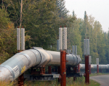
When permafrost thaws, it can cause the soil to sink or settle, damaging structures built upon or within that soil. A warming climate and burial of supports for the Trans-Alaska Pipeline System both contribute to thawing of the permafrost around the pipeline. In locations on the pipeline route where soils were ice-rich, a unique above-ground system was developed to keep the ground cool. Thermal siphons were designed to disperse heat to the air that would otherwise be transferred to the soil, and these siphons were placed on the pilings that support the pipeline. While this unique technology added significant expense to the pipeline construction, it helps to greatly increase the useful lifetime of this structure.29
Coastal Areas
Coastal storms increase risks to villages and fishing fleets.
Alaska has more coastline than the other 49 states combined. Frequent storms in the Gulf of Alaska and the Bering, Chukchi, and Beaufort Seas already affect the coasts during much of the year. Alaska’s coastlines, many of which are low in elevation, are increasingly threatened by a combination of the loss of their protective sea ice buffer, increasing storm activity, and thawing coastal permafrost.
Annual Number of Storms at Barrow Alaska, 1950-2004 (northernmost town in the United States)") The number of coastal storms has generally increased as the amount of ice along the coast has decreased. This increase threatens commercial activity and communities in Alaska. The blue line indicates the annual number of open-water storms, those occurring in primarily ice-free water (July to December). The purple line indicates the number of storms occurring when thick sea ice is present (January to June). The black and green lines are smoothed using 5-year averages. Image Reference: University of Alaska30
The number of coastal storms has generally increased as the amount of ice along the coast has decreased. This increase threatens commercial activity and communities in Alaska. The blue line indicates the annual number of open-water storms, those occurring in primarily ice-free water (July to December). The purple line indicates the number of storms occurring when thick sea ice is present (January to June). The black and green lines are smoothed using 5-year averages. Image Reference: University of Alaska30
Increasing storm activity in autumn in recent years31 has delayed or prevented barge operations that supply coastal communities with fuel. Commercial fishing fleets and other marine traffic are also strongly affected by Bering Sea storms. High-wind events have become more frequent along the western and northern coasts. The same regions are experiencing increasingly long sea-ice-free seasons and hence longer periods during which coastal areas are especially vulnerable to wind and wave damage. Downtown streets in Nome, Alaska, have flooded in recent years. Coastal erosion is causing the shorelines of some areas to retreat at average rates of tens of feet per year. The ground beneath several native communities is literally crumbling into the sea, forcing residents to confront difficult and expensive choices between relocation and engineering strategies that require continuing investments despite their uncertain effectiveness (see Society sector). The rate of erosion along Alaska’s northeastern coastline has doubled over the past 50 years.7
Projected Coastal Erosion, 2007 to 2027 Newtok, Western Alaska Many of Alaska’s coastlines are eroding rapidly; the disappearance of coastal land is forcing communities to relocate. The 2007 line on the image indicates where Newtok, Alaska’s shoreline had eroded to by 2007. The other lines are projected assuming a conservative erosion rate of 36 to 83 feet per year; however, Newtok residents reported a July 2003 erosion rate of 110 feet per year. Image Reference: U.S. Army Corps of Engineers32
Over this century, an increase of sea surface temperatures and a reduction of ice cover are likely to lead to northward shifts in the Pacific storm track and increased impacts on coastal Alaska.33,34 Climate models project the Bering Sea to experience the largest decreases in atmospheric pressure in the Northern Hemisphere, suggesting an increase in storm activity in the region.4 In addition, the longer ice-free season is likely to make more heat and moisture available for storms in the Arctic Ocean, increasing their frequency and/or intensity.
Fisheries and Marine Ecosystems
Displacement of marine species will affect key fisheries.
Alaska leads the United States in the value of its commercial fishing catch. Most of the nation’s salmon, crab, halibut, and herring come from Alaska. In addition, many Native communities depend on local harvests of fish, walruses, seals, whales, seabirds, and other marine species for their food supply. Climate change causes significant alterations in marine ecosystems with important implications for fisheries. Ocean acidification associated with a rising carbon dioxide concentration represents an additional threat to coldwater marine ecosystems35,36 (see Ecosystems sector and Coasts region).
One of the most productive areas for Alaska fisheries is the northern Bering Sea off Alaska’s west coast. The world’s largest single fishery is the Bering Sea pollock fishery, which has undergone major declines in recent years. Over much of the past decade, as air and water temperatures rose, sea ice in this region declined sharply. Populations of fish, seabirds, seals, walruses, and other species depend on plankton blooms that are regulated by the extent and location of the ice edge in spring. As the sea ice retreats, the location, timing, and species composition of the plankton blooms changes, reducing the amount of food reaching the living things on the ocean floor. This radically changes the species composition and populations of fish and other marine life forms, with significant repercussions for fisheries8 (see Ecosystems sector).
Over the course of this century, changes already observed on the shallow shelf of the northern Bering Sea are likely to affect a much broader portion of the Pacific-influenced sector of the Arctic Ocean. As such changes occur, the most productive commercial fisheries are likely to become more distant from existing fishing ports and processing infrastructure, requiring either relocation or greater investment in transportation time and fuel costs. These changes will also affect the ability of Native Peoples to successfully hunt and fish for the food they need to survive. Coastal communities are already noticing a displacement of walrus and seal populations. Bottom-feeding walrus populations are threatened when their sea ice platform retreats from the shallow coastal feeding grounds on which they depend.37
Marine Species Shifting Northward 1982 to 2007 As air and water temperatures rise, marine species are moving northward, affecting fisheries, ecosystems, and coastal communities that depend on the food source. On average, by 2006, the center of the range for the examined species moved 19 miles north of their 1982 locations. Image Reference: Mueter and Litzow38
References
- 1. [93] various. footnote 93., 2009.
- 2. a. b. [501] Fitzpatrick, J., R. B. Alley, J. Brigham-Grette, G. H. Miller, L. Polyak, and M. Serreze. "Preface: Why and How to Use this Synthesis and Assessment Report." In Past Climate Variability and Change in the Arctic and at High Latitude, 8-21. Vol. Synthesis and Assessment Product 1.2. Reston, VA: U.S. Geological Survey, 2008.
- 3. a. b. [220] ACIA. Impacts of a Warming Arctic: Arctic Climate Impact Assessment. Cambridge, UK and New York, NY: Cambridge University Press, 2004.
- 4. a. b. [90] Meehl, G. A., T. F. Stocker, W. D. Collins, P. Friedlingstein, A. T. Gaye, JM Gregory, A. Kitoh, R. Knutti, J. M. Murphy, A. Noda et al. "Global Climate Projections." In Climate Change 2007: The Physical Basis, edited by S. Solomon, D. Qin, M. Manning, Z. Chen, M. Marquis, K. B. Averyt, M. Tignor and H. L. Miller, 747-845. Vol. Contribution of Working Group I to the Fourth Assessment Report of the Intergovernmental Panel on Climate Change. Cambridge, UK and New York, NY: Cambridge University Press, 2007.
- 5. [502] various. footnote 502., 2009.
- 6. a. b. c. [91] various. footnote 91., 2009.
- 7. a. b. [522] Jones, B. M., C. D. Arp, M. T. Jorgenson, K. M. Hinkel, J. A. Schmutz, and P. L. Flint. "Increase in the Rate and Uniformity of Coastline Erosion in Arctic Alaska." Geophysical Research Letters 36 (2009): -.
- 8. a. b. [527] Grebmeier, J. M., J. E. Overland, S. E. Moore, E. V. Farley, E. C. Carmack, L. W. Cooper, K. E. Frey, J. H. Helle, F. A. McLaughlin, and S. L. McNutt. "A Major Ecosystem Shift in the Northern Bering Sea." Science 311, no. 5766 (2006): 1461-1464.
- 9. [503] Euskirchen, E. S., A. D. McGuire, D. W. Kicklighter, Q. Zhuang, J. S. Clein, R. J. Dargaville, D. G. Dye, J. S. Kimball, K. C. McDonald, J. M. Melillo et al. "Importance of Recent Shifts in Soil Thermal Dynamics on Growing Season Length, Productivity, and Carbon Sequestration in Terrestrial High-latitude Ecosystems." Global Change Biology 12, no. 4 (2006): 731-750.
- 10. [504] Euskirchen, E. S., A. D. McGuire, and F. S. Chapin III. "Energy Feedbacks of Northern High-latitude Ecosystems to the Climate System due to Reduced Snow Cover during 20th Century Warming." Global Change Biology 13, no. 11 (2007): 2425-2438.
- 11. [505] Barber, V. A., G. P. Juday, and B. P. Finney. "Reduced Growth of Alaskan White Spruce in the Twentieth Century from Temperature-induced Drought Stress." Nature 405, no. 6787 (2000): 668-673.
- 12. a. b. c. d. e. [506] Juday, G. P., V. A. Barber, P. Duffy, H. Linderholm, T. S. Rupp, S. Sparrow, E. Vaganov, and J. Yarie. "Forests, Land Management, and Agriculture." In Arctic Climate Impact Assessment, 781-862. Cambridge, UK and New York, NY: Cambridge University Press, 2005.
- 13. a. b. [507] Balshi, M. S., A. D. McGuirez, P. Duffy, M. Flannigan, J. Walsh, and J. Melillo. "Assessing the Response of Area Burned to Changing Climate in Western Boreal North America using a Multivariate Adaptive Regression Splines (MARS) Approach." Global Change Biology 15, no. 3 (2009): 578-600.
- 14. [243] Ryan, M. G., S. R. Archer, R. Birdsey, C. Dahm, L. Heath, J. Hicke, D. Hollinger, T. Huxman, G. Okin, R. Oren et al. "Land Resources." In The Effects of Climate Change on Agriculture, Land Resources, Water Resources, and Biodiversity in the United States, edited by P. Backlund, A. Janetos, D. Schimel, J. Hatfield, K. Boote, P. Fay, L. Hahn, C. Izaurralde, B. A. Kimball, T. Mader et al., 75-120. Vol. Synthesis and Assessment Product 3.3. Washington, D.C.: U.S. Department of Agriculture, 2008.
- 15. [508] Berman, M., G. P. Juday, and R. Burnside. "Climate Change and Alaska's Forests: People, Problems, and Policies." In Assessing the Consequences of Climate Change for Alaska and the Bering Sea Region, edited by G. Weller and P. A. Anderson, 21-42. Proceedings of a Workshop at the University of Alaska Fairbanks, 29-30 October 1998. Fairbanks, Alaska: Center for Global Change and Arctic System Research, University of Alaska Fairbanks, 1999.
- 16. [509] Fleming, R. A., and W. J. A. Volney. "Effects of Climate Change on Insect Defoliator Processes in Canada's Boreal Forest: Some Plausible Scenarios." Water, Soil, and Air Pollution 82, no. 1-2 (1995): 445-454.
- 17. [510] Kasischke, E. S., and M. R. Turetsky. "Recent Changes in the Fire Regime across the North American Boreal Region - Spatial and Temporal Patterns of Burning across Canada and Alaska." Geophysical Research Letters 33 (2006): -.
- 18. [511] Chapin III, F. S., S. F. Trainor, O. Huntington, A. L. Lovecraft, E. Zavaleta, D. C. Natcher, A. D. McGuire, J. L. Nelson, L. Ray, M. Calef et al. "Increasing Wildfire in Alaska's Boreal Forest: Pathways to Potential Solutions of a Wicked Problem." BioScience 58, no. 6 (2008): 531-540.
- 19. [512] Berner, J., and C. Furgal. "Human Health." In Arctic Climate Impact Assessment, 863-906. Cambridge, UK and New York, NY: Cambridge University Press, 2005.
- 20. a. b. [514] Riordan, B., D. Verbyla, and A. D. McGuire. "Shrinking Ponds in Subarctic Alaska Based on 1950-2002 Remotely Sensed Images." Journal of Geophysical Research-Biogeosciences 111 (2006).
- 21. [513] Klein, E., E. E. Berg, and R. Dial. "Wetland Drying and Succession across the Kenai Peninsula Lowlands, South-central Alaska." Canadian Journal of Forest Research 35, no. 8 (2005): 1931-1941.
- 22. [517] Brown, J., and V. E. Romanovsky. "Report from the International Permafrost Association: State of Permafrost in the First Decade of the 21(st) Century." Permafrost and Periglacial Processes 19, no. 2 (2008): 255-260.
- 23. [149] Lettenmaier, D., D. Major, L. Poff, and S. Running. "Water Resources." In The Effects of Climate Change on Agriculture, Land Resources, Water Resources and Biodiversity in the United States, edited by P. Backlund, A. Janetos, D. Schimel, J. Hatfield, K. Boote, P. Fay, L. Hahn, C. Izaurralde, B. A. Kimball, T. Mader et al., 121-150. Vol. Synthesis and Assessment Product 4.3. Washington, D.C.: U.S. Department of Agriculture, 2008.
- 24. [515] Osterkamp, T. E.. "Characteristics of the Recent Warming of Permafrost in Alaska." Journal of Geophysical Research 112 (2007).
- 25. [518] Busey, R. C., L. D. Hinzman, J. J. Cassano, and E. Cassano. Permafrost Distributions on the Seward Peninsula: Past, Present, and Future In Ninth International Conference on Permafrost, Edited by D. L. Kane and K. M. Hinkel. University of Alaska Fairbanks: Institute of Northern Engineering, University of Alaska Fairbanks, 2008.
- 26. [516] Instanes, A., O. Anisimov, L. Brigham, D. Goering, L. N. Khrustalev, B. Ladanyi, and J. O. Larsen. "Infrastructure: Buildings, Support Systems, and Industrial Facilities." In Arctic Climate Impact Assessment, 907-944. Cambridge, UK and New York, NY: Cambridge University Press, 2005.
- 27. [230] Larsen, P. H., S. Goldsmith, O. Smith, M. L. Wilson, K. Strzepek, P. Chinowsky, and B. Saylor. "Estimating Future Costs for Alaska Public Infrastructure at Risk from Climate Change." Global Environmental Change 18, no. 3 (2008): 442-457.
- 28. [245] Hinzman, L. D., N. D. Bettez, W. R. Bolton, F. S. Chapin, M. B. Dyurgerov, C. L. Fastie, B. Griffith, R. D. Hollister, A. Hope, H. P. Huntington et al. "Evidence and Implications of Recent Climate Change in Northern Alaska and Other Arctic Regions." Climatic Change 72, no. 3 (2005): 251-298.
- 29. [519] Shumaker, V. O.. The Alaska Pipeline. New York, NY: Julian Messner, 1979.
- 30. [525] various. footnote 525., 2009.
- 31. [520] Bengtsson, L., K. I. Hodges, and E. Roeckner. "Storm Tracks and Climate Change." Journal of Climate 19, no. 15 (2006): 3518-3543.
- 32. [521] of Engineers, Army Corps U. S.. Newtok Evacuation Center, Mertarvik, Nelson Island, Alaska - Revised Environmental Assessment. Elmendorf AFB - Anchorage, AK: U.S. Army Corps of Engineers, Alaska District, 2008.
- 33. [523] Yin, J. H.. "A Consistent Poleward Shift of the Storm Tracks in Simulations of 21st Century Climate." Geophysical Research Letters 32 (2005): -.
- 34. [524] Salathe, E. P.. "Influences of a Shift in North Pacific Storm Tracks on Western North American Precipitation under Global Warming." Geophysical Research Letters 33 (2006): -.
- 35. [23] Orr, JC, V. J. Fabry, O. Aumont, L. Bopp, SC Doney, R. A. Feely, A. Gnanadesikan, N. Gruber, A. Ishida, F. Joos et al. "Anthropogenic ocean acidification over the twenty-first century and its impact on calcifying organisms." Nature 437, no. 7059 (2005): 681-686.
- 36. [526] Feely, R. A., C. L. Sabine, K. Lee, W. Berelson, J. Kleypas, V. J. Fabry, and F. J. Millero. "Impact of Anthropogenic CO2 on the CaCO3 System in the Oceans." Science 305, no. 5682 (2004): 362-366.
- 37. [528] Ray, G. C., J. McCormick-Ray, P. Berg, and H. E. Epstein. "Pacific Walrus: Benthic Bioturbator of Beringia." Journal of Experimental Marine Biology and Ecology 330, no. 1 (2006): 403-419.
- 38. [529] Mueter, F. J., and M. A. Litzow. "Sea Ice Retreat Alters the Biogeography of the Bering Sea Continental Shelf." Ecological Applications 18, no. 2 (2008): 309-320.