The content of this website is no longer being updated. For information on current assessment activities, please visit http://www.globalchange.gov/what-we-do/assessment
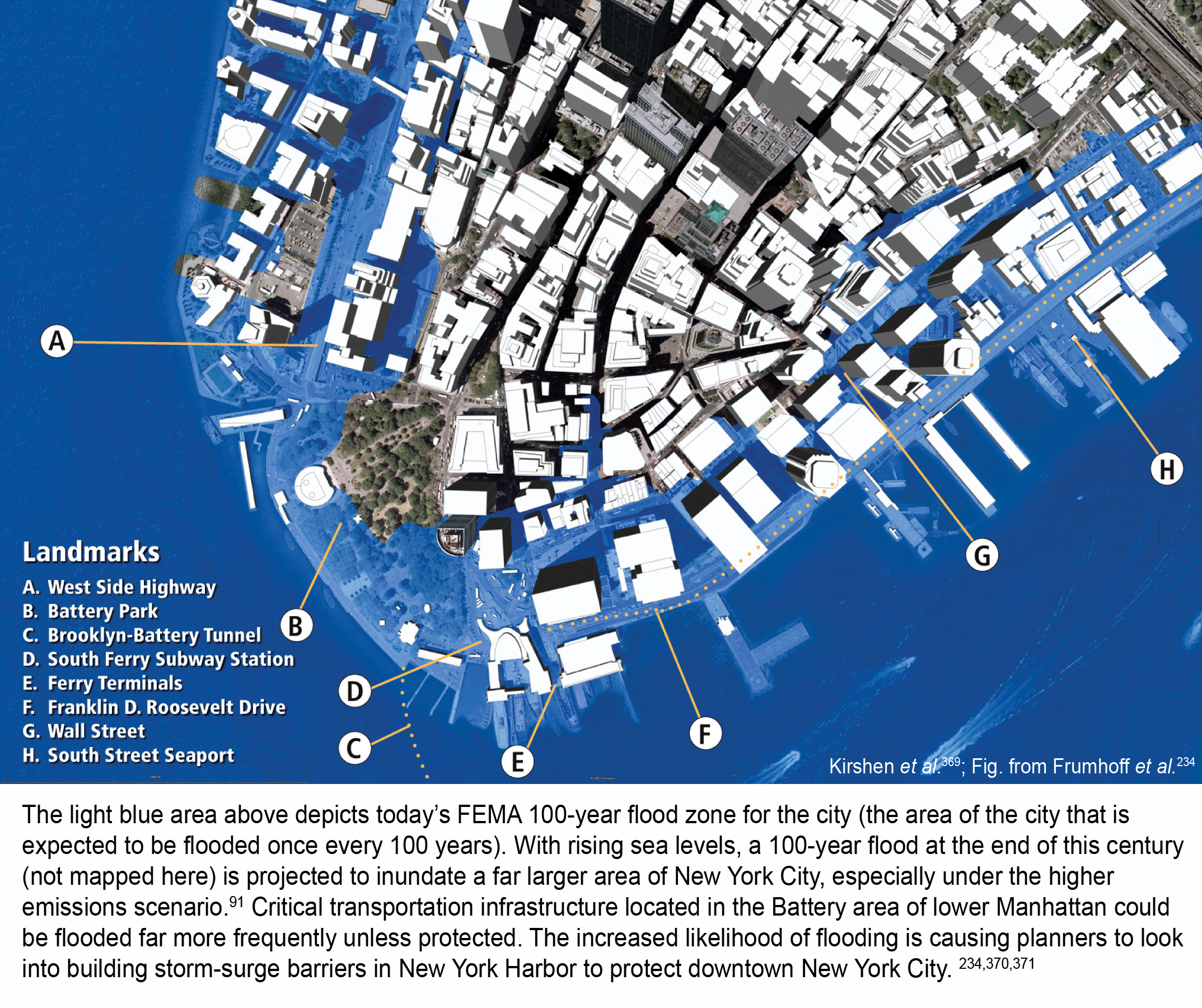
Increased Flood Risk in New York City

The light blue area above depicts today’s FEMA 100-year flood zone for the city (the area of the city that is expected to be flooded once every 100 years). With rising sea levels, a 100-year flood at the end of this century (not mapped here) is projected to inundate a far larger area of New York City, especially under the higher emissions scenario.1 Critical transportation infrastructure located in the Battery area of lower Manhattan could be flooded far more frequently unless protected. The increased likelihood of flooding is causing planners to look into building storm-surge barriers in New York Harbor to protect downtown New York City. 2,3,4 Image Reference: Kirshen et al.5; Image Source: Frumhoff et al.2
References
- 1. [91] various. footnote 91., 2009.
- 2. a. b. [234] Frumhoff, P. C., J. J. McCarthy, J. Melillo, S. C. Moser, and D. Wuebbles. Confronting Climate Change in the U. S. Northeast: Science, Impacts, and Solutions. Vol. Synthesis Report of the Northeast Climate Impacts Assessment. Cambridge, MA: Union of Concerned Scientists, 2007.
- 3. [370] Bowman, M., D. Hill, F. Buonaiuto, B. Colle, R. Flood, R. Wilson, R. Hunter, and J. Wang. "Threats and Responses Associated with Rapid Climate Change in Metropolitan New York." In Sudden and Disruptive Climate Change: Exploring the Real Risks and How We Can Avoid Them, edited by M. C. MacCracken, F. Moore and J. C. Topping Jr., 119-142. London, UK and Sterling, VA: Earthscan, 2008.
- 4. [371] Titus, J. G., K. E. Anderson, D. R. Cahoon, D. B. Gesch, S. K. Gill, B. T. Butierrez, E. R. Thieler, and S. J. Williams. "Ongoing Adaptation." In Coastal Elevations and Sensitivity to Sea-level Rise: A Focus on the Mid-Atlantic Region, 157-162. Vol. Synthesis Assessment Product 4.1. Washington, D.C.: U.S. Environmental Protection Agency, 2009.
- 5. [369] Kirshen, P., C. Watson, E. Douglas, A. Gontz, J. Lee, and Y. Tian. "Coastal Flooding in the Northeastern United States Due to Climate Change." Mitigation and Adaptation Strategies for Global Change 13, no. 5-6 (2008): 437-451.
Summary
| High-resolution | High-resolution JPEG |
|---|---|
| Photo Credit | Applied Science Associates, Inc. |